The demonstration site of Dadès Valley - Nexus diagnosis
The demonstration site of Dadès Valley - Nexus diagnosis
The first step at each site is to establish an initial analytical baseline that enables an integrated understanding, shared with territorial stakeholders, of the interactions, synergies and trade-offs among the four Nexus components—water, environment, energy, and agriculture and food—as well as the constraints and opportunities specific to each site.
The study area and its resources
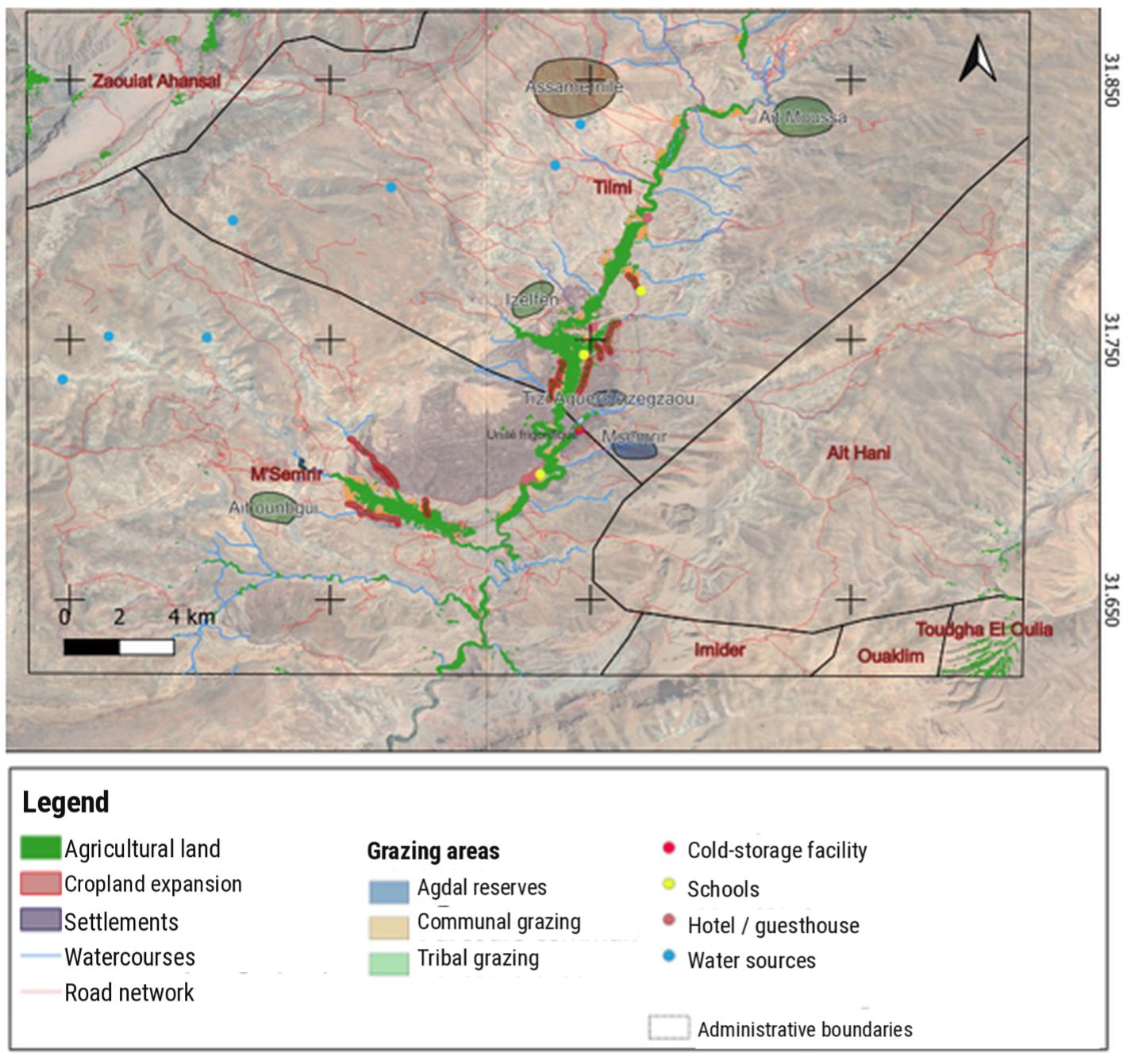
Located in the High Atlas Mountains, the M’Semrir–Tilmi area is a mountain oasis characterised by an arid climate and cool winters. It lies in Tinghir Province, at the foot of the High Atlas, at an elevation of 1,900 m. Access is difficult, as only one road links it to neighbouring areas. The territory is shared by three tribal groups—the Aït Hadiddou, Aït Marghad and Aït Atta—and comprises two communes: Tilmi, home to the Aït Hadiddou and Aït Marghad, and M’Semrir, occupied by the Aït Atta. It encompasses four distinct areas—central M’Semrir, Oussikis–Taadadate, Aït Marghad and Aït Hadiddou—whose differing characteristics and strategies shape economic activities, especially agriculture and livestock rearing. Central M’Semrir faces severe land fragmentation and topographical constraints that limit the expansion of farmland. It has a high concentration of tertiary activities, including trade, services and tourism. In Oussikis–Taadadate and Aït Marghad, farming focuses on apple production, favoured by the relatively flat terrain. In Aït Hadiddou, transhumant livestock rearing predominates alongside subsistence and fodder cropping.
The Dadès River is the main perennial watercourse, flowing through Tilmi and M’Semrir. Its low summer flows coincide with peaks in agricultural demand, creating structural water stress. Its perennial tributary, the Oussikis River, supplies the Oussikis–Taadadate area in particular. Several springs contribute to the baseflow of the rivers. Located mainly in grazing areas, they are strategic watering points, especially for transhumant livestock.
Sedimentation has considerably reduced the functional capacity of the Oussikis Dam. It became completely inoperative in 2010 and no longer fulfils either its water-storage role or its function of protecting against flooding and debris flows. Although the drilling of new wells has slightly increased available water volumes, supply remains structurally insufficient to meet domestic needs, and shortages recur in summer. The practice of some households washing clothes in the riverbed illustrates their dependence on natural water systems for domestic purposes and raises concerns about water quality.
Agricultural irrigation is by far the largest water use, accounting for most withdrawals, particularly during summer. Drinking water and domestic uses form the second-largest category of consumption. These needs are relatively stable but also peak in summer. Although livestock watering uses smaller volumes, it remains strategically important for supporting pastoral activities.
Drinking Water Users’ Associations (AUEP) manage drinking water services within defined territories. The communes undertake measures to improve water and demand management with technical and financial support from the Regional Office for Agricultural Development of Ouarzazate (ORMVA), which can mobilise funding from different sources and provides farmer training, as well as support from the River Basin Agency and the National Agency for Water and Forests (ANEF).
Energy: the transition to solar-powered agricultural pumping
Energy is central to the interactions between water, agriculture and the development of local production systems. It is primarily involved in collective and individual irrigation and in the processing and storage of agricultural products. For collective irrigation, the OASIL programme (2017–2021), jointly implemented by the Ministry of Energy Transition and Sustainable Development, the Ministry of Agriculture, the National Agency for the Development of Oasis Areas and Argan Trees (ANDZOA), the National Institute for Agricultural Research (INRA) and FAO, with support from local and regional actors, enabled the installation of solar-powered wells and boreholes for irrigation and livestock watering. For individual wells, diesel- and butane-powered pumps remain the main energy sources, exposing farms to fuel price volatility and sharp increases in operating costs. In this context, some farmers have begun adopting individual solar pumping systems on an isolated and experimental basis as a more economical alternative.
As regards product valorisation, the M’Semrir–Tilmi apple cold-storage facility, built in 2018, is currently supplied by the national electricity grid. A possible transition to renewable energy, particularly solar power, is being considered to improve the economic viability of the value chain and reduce the facility’s carbon footprint.
Agriculture and food: a system structured around livestock and apple production
The M’Semrir–Tilmi area is characterised by an agropastoral system based mainly on D’man sheep, together with a small number of goats and occasionally one or two cows whose milk is consumed by the household or given as a gift. Over just a few decades, this system has undergone profound changes. The gradual settlement of livestock herders, driven by cumulative climate constraints and changes in mobility patterns, has been accompanied by the expansion of irrigated apple orchards (cold temperatures are necessary for fruiting), the growth of alfalfa cultivation and the progressive formation of producer organisations (first cooperatives, then economic interest groups). An apple cold-storage facility has also been brought into operation, and processing units are being planned.
At the same time, livestock rearing has become largely integrated into settled farms, with growing dependence on supplementary feed because of the decline in natural rangeland productivity, although transhumant forms of livestock keeping have not disappeared entirely.
Land fragmentation, the economic vulnerability of small farms and limited diversification of non-agricultural activities have contributed to sustained youth migration, reshaping demographic balances, knowledge transmission and local investment capacity.
The study area can be divided into three agroecological zones from north to south:
- a high-mountain zone where transhumance is the main activity. The Saghro breed, a hardy breed well adapted to transhumance, is most commonly used by herders. Rangelands are collective lands managed by the region’s tribes. Subsistence and fodder crops are also grown.
- an intermediate rangeland zone consisting of collective lands where semi-transhumant and sedentary livestock farming, mainly involving the Timehdit breed, predominates. Agricultural terraces have been established, and wells have been dug because of the distance from the river.
- an agricultural oasis zone occupied mainly by apple orchards, where D’man sheep are reared primarily in intensive systems. Despite their limited area (an average of 0.7 ha per farm), these agricultural lands constitute an essential productive asset.
Irrigation
Surface water is conveyed mainly through an old network of seguias (earthen canals that have gradually been lined with concrete since the late 1980s), which forms the backbone of the distribution system. Network efficiency is low because of water losses and deteriorating infrastructure. There are major inequalities between upstream and downstream users, with flow reductions of up to 42% at the downstream end of the network. In addition, the proliferation of collective and private wells raises concerns about unregulated aquifer overexploitation and inequalities among farmers. Irrigation water is shared among rights holders through rotational water turns. Each tribe receives a specified number of irrigation days in a predetermined order over successive cycles. Monitoring and enforcement are carried out by a Nader, appointed by each tribe to distribute water according to the agreed schedule, ensure compliance with the rules and collect fines for infringements. This customary practice can no longer bridge the growing gap between water demand and availability.
Irrigation remains predominantly gravity-fed, although some farms in agricultural expansion areas have introduced plot-level drip irrigation. Adoption of this technique remains limited by structural constraints: complex land-tenure arrangements that hinder investment and contracting services; land fragmentation and small plot sizes that reduce economies of scale and equipment profitability; and difficulties accessing public subsidies and support programmes. In addition, some farmers divert spring water through small temporary structures when pressure on the resource increases.
Fragile ecosystems requiring protection
The study area includes farmland along the river, terraced agricultural extensions, high-altitude rangelands and transhumance areas. Together, these form a landscape in which human activities and natural processes are closely interconnected through traditional management practices. Rangeland productivity is declining significantly under the combined effects of increasing climatic constraints and overexploitation. Recurrent droughts reduce fodder availability and plant diversity, while torrential rainfall accelerates soil erosion. The loss of certain plant species is also causing a shortage of firewood.
Among the protected areas, traditional pastoral reserves known as agdals are seasonally closed and governed by long-standing customary rules that have helped prevent overexploitation of grazing resources. Some agdals historically served as nature reserves to protect particular species, notably the Barbary sheep. Today, this traditional management system faces several challenges: declining involvement of younger generations and local residents, pressure from agricultural expansion, and the proliferation of individual wells at the expense of collective management. Some agdals have lost their protected status and function because no one is willing to take on monitoring responsibilities; they are now managed by the water and forestry authorities.
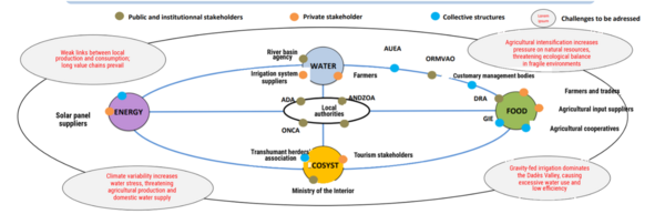
Water is a source of recurrent tensions, revealing a multidimensional imbalance between supply and demand that is exacerbated by infrastructure vulnerabilities and climate change. Strong seasonality, with high flows in winter and spring followed by low summer flows, conflicts with an agricultural calendar dominated by apple orchards. Customary allocation rules no longer reflect the current distribution of agricultural land, and the rule whereby 'buying land does not mean buying water rights' forces downstream tribes to compensate through groundwater extraction. In the absence of regulation by customary institutions, this creates a risk of aquifer overexploitation. The growing number of formal actors involved in water management, each with its own intervention logic, budgets and programmes, creates planning inconsistencies and coordination challenges at all levels of governance. Because water is the main link between agriculture, livestock rearing, food and the environment, the absence of a collective mechanism to regulate and coordinate withdrawals makes it urgent to revise management rules and introduce forms of water governance suited to current conditions.
Ecosystem stability is also being undermined by agricultural intensification. The gradual disappearance of emblematic species reflects increasing pressure on ecosystems. Growing use of chemical inputs (fertilisers and pesticides) without technical advice exposes soils and water to progressive degradation. Household wastewater contributes to localised organic and chemical contamination. Soil erosion, declining rangeland productivity and the gradual disappearance of agdal areas indicate a loss of ecological regulation. Customary institutions, which once ensured sustainable rangeland management and water distribution, have weakened, giving way to uncoordinated uses that accelerate resource degradation. Meanwhile, flood-protection infrastructure (gabions and retention basins) is often poorly maintained or inadequately designed, increasing farmland vulnerability to debris flows and climate variability.
The growth of apple production has profoundly transformed the territory’s economy and social organisation. Formerly structured around mixed systems combining fruit trees, food crops and transhumant livestock, the valley is increasingly moving towards specialisation. This change has increased cash income for some producers but has also created a strong dependence on a single product, exposing the territory to price fluctuations, climatic hazards and market crises. The expansion of this monoculture goes hand in hand with intensive water use and increased pressure on collective lands, to the detriment of livestock and rangelands. The gradual settlement of herds, reduction of grazing areas and loss of knowledge associated with pastoral mobility are undermining the balance between agriculture and livestock rearing that once sustained the ecological and economic viability of the oasis system. Tourism, still an emerging activity, struggles to find a place in this agriculture-dominated setting.
The territory now faces the challenge of finding a new balance among fruit production, livestock rearing and rural tourism—one that reconciles profitability, economic diversity and natural resource conservation. Yet the crisis in M’Semrir–Tilmi is also a governance crisis. The territory suffers from fragmented initiatives, poor coordination across scales of action and an inability to define collective priorities and build a coherent development project. Stakeholders have divergent interests: apple producers seek to expand their orchards; herders defend access to grazing areas; public institutions pursue sector-specific strategies; local associations seek recognition; and young people seek employment and mobility opportunities.
Cross-sectoral challenges facing the territory
The analysis of M’Semrir–Tilmi highlights the need for structural changes in resource governance and stakeholder coordination. Tensions surrounding water, agricultural specialisation and the weakening of local institutions call for an integrated approach that brings together the environmental, social and economic dimensions of territorial development. Such an approach could be based on:
- establishing a territorial consultation framework bringing together the main public and community stakeholders, jointly coordinated by the rural communes of M’Semrir and Tilmi and ANDZOA
- creating a local system for monitoring and observing resources and their uses, including changing agricultural practices and the dynamics and socioeconomic impacts of soil and rangeland degradation
- revising agricultural support mechanisms to incorporate criteria relating to water-use efficiency, climate resilience and ecosystem sustainability (crop diversification, rehabilitation of traditional irrigation systems, and promotion of locally adapted agroecological practices and techniques)
- strengthening coordination between customary structures and formal management bodies, including Jmaa committees, the Nader and seguia institutions on the one hand, and agricultural water users’ associations (AUEA), agricultural cooperatives and ethnopastoral cooperatives on the other.
Challenges and stakeholders of the Demonstration site Dadès Valley
Opportunities for the territory: initiatives and stakeholders that can strengthen resilience and sustainability
A number of initiatives are already in place, reflecting a gradual adaptation to the territory’s challenges. They combine local knowledge, community action and institutional support, although their scope remains limited.
Deployment of solar pumping for irrigation
Since 2018, solar pumps have become increasingly common among farmers in M’Semrir–Tilmi. Supported by programmes under the Green Morocco Plan and subsequently Generation Green, this solution has increased farmers’ autonomy and helped maintain agricultural activity during prolonged droughts. It has reduced energy costs associated with pumping and ensured more regular access to irrigation water, particularly in areas far from the gravity-fed network. However, in the absence of regulatory mechanisms, it also encourages groundwater overexploitation.
Rehabilitation and maintenance of traditional irrigation systems
Local communities, supported by the Regional Office for Agricultural Development of Ouarzazate (ORMVA) and ANDZOA, have undertaken the rehabilitation of seguias (traditional irrigation canals) and khettaras (underground qanat-type galleries) to improve water distribution and reduce losses.
Gradual introduction of water-saving techniques
Some pilot farms, particularly in agricultural expansion areas, have introduced micro-irrigation or gravity-fed drip irrigation systems. However, these practices remain occasional and are not widely adopted.
Community management of water and rangelands
The progressive drying-up of high-altitude watering points and declining river flows are prompting farmers to organise collectively and share wells and groundwater resources. Alongside customary governance arrangements, including tribal Jmaa committees, the Nader and seguia institutions, agricultural water users’ associations (AUEA) are gradually formalising collective management and facilitating coordination with the Regional Office for Agricultural Development of Ouarzazate (ORMVAO).
Economic organisation around apples and agricultural diversification
The Apple Economic Interest Group (GIE Pomme) provides a successful example of resource pooling at the intercommunal level. It manages cold-storage facilities and collective marketing, helping stabilise income and reduce producers’ vulnerability. In addition, several agricultural cooperatives (honey, aromatic and medicinal plants) and women’s cooperatives have emerged with support from the National Initiative for Human Development (INDH) and ANDZOA, strengthening economic diversification, women’s empowerment and the valorisation of local products.
Protection of pastoral rangelands
In some intertribal areas, livestock breeders’ associations have organised to maintain pastoral mobility and protect traditional agdals. These initiatives, often supported by local authorities or ANEF services, reflect efforts to restore the balance between irrigated agriculture and pastoral livestock rearing.
Oasis development
ANDZOA programmes aim to foster ecological resilience, sustainable natural resource management and the economic valorisation of oasis products. In the eastern High Atlas, the agency supports the restoration of water infrastructure, the revitalisation of collective lands and the promotion of local governance.
Improving living conditions
The National Initiative for Human Development (INDH) regularly finances community projects to improve living conditions and access to drinking water, promote income-generating activities and reduce rural poverty. Decentralised cooperation mechanisms and local NGOs (drinking-water programmes, small agricultural projects and community-based tourism) contribute to economic diversification and help local populations remain in the area.
Technical support for producers
ORMVAO and ONCA provide producers with support for irrigation, training and the development of fruit crops.
Innovations proposed in the MORFeuS project
These innovations are organised around two strategic pillars: the creation of a sustainable territorial label and a territorial intelligence platform, complemented by technical and institutional measures to support the Nexus transition.
The proposed labelling strategy goes beyond conventional local-product labels focused on the commercial quality of a single product. Its aim is to establish a collective territorial project that brings together agricultural, pastoral, energy and environmental practices within a shared sustainability framework to guide stakeholders in their decision-making. Its strength lies in a co-construction process and shared reflection on what constitutes the value of the territory.
This approach is linked to the development of a Territorial Intelligence Platform, conceived as a territorial observatory, foresight tool and infrastructure providing the data, indicators and insights needed to build and monitor the labelling process. Designed for a collective and policy-oriented purpose, the tool will help steer the territory towards a shared governance model for sustainable development.
The platform seeks to create a space where public, professional, community and scientific stakeholders can share information, co-produce diagnoses, plan coordinated actions and monitor the effects of their decisions over time. It will integrate data from diverse sources, including participatory surveys, environmental sensors, institutional databases, satellite imagery, and socioeconomic and land-tenure information. Linking data from different sources will make it possible to construct composite indices, such as indicators of water vulnerability, energy performance, agroecological sustainability and socioeconomic resilience.
By browsing our site you accept the installation and use cookies on your computer.
Know more
Our use of cookies
Cookies are a set of data stored on a user’s device when the user browses a web site. The data is in a file containing an ID number, the name of the server which deposited it and, in some cases, an expiry date. We use cookies to record information about your visit, language of preference, and other parameters on the site in order to optimise your next visit and make the site even more useful to you.
To improve your experience, we use cookies to store certain browsing information and provide secure navigation, and to collect statistics with a view to improve the site’s features. For a complete list of the cookies we use, download “Ghostery”, a free plug-in for browsers which can detect, and, in some cases, block cookies.
You can also visit the CNIL web site for instructions on how to configure your browser to manage cookie storage on your device.
In the case of third-party advertising cookies, you can also visit the following site: https://www.youronlinechoices.com/fr/controler-ses-cookies/, offered by digital advertising professionals within the European Digital Advertising Alliance (EDAA). From the site, you can deny or accept the cookies used by advertising professionals who are members.
It is also possible to block certain third-party cookies directly via publishers:
Cookie type
Means of blocking
Analytical and performance cookies
Realytics Google Analytics Spoteffects Optimizely
Targeted advertising cookies
DoubleClick Mediarithmics
The following types of cookies may be used on our websites:
Mandatory cookies
Functional cookies
Social media and advertising cookies
These cookies are needed to ensure the proper functioning of the site and cannot be disabled. They help ensure a secure connection and the basic availability of our website.
These cookies allow us to analyse site use in order to measure and optimise performance. They allow us to store your sign-in information and display the different components of our website in a more coherent way.
These cookies are used by advertising agencies such as Google and by social media sites such as LinkedIn and Facebook. Among other things, they allow pages to be shared on social media, the posting of comments, and the publication (on our site or elsewhere) of ads that reflect your centres of interest.
Our EZPublish content management system (CMS) uses CAS and PHP session cookies and the New Relic cookie for monitoring purposes (IP, response times). These cookies are deleted at the end of the browsing session (when you log off or close your browser window)
Our EZPublish content management system (CMS) uses the XiTi cookie to measure traffic. Our service provider is AT Internet. This company stores data (IPs, date and time of access, length of the visit and pages viewed) for six months
Our EZPublish content management system (CMS) does not use this type of cookie.
For more information about the cookies we use, contact INRAE’s Data Protection Officer by email at cil-dpo@inra.fr or by post at:
INRAE 24, chemin de Borde Rouge –Auzeville – CS52627 31326 Castanet Tolosan cedex - France