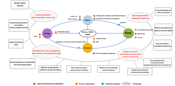
The first step for each study site is to establish an initial analytical baseline to develop an integrated understanding, shared with local stakeholders, of the interactions, synergies and trade-offs between the four components of the Nexus WEFE - Water, Environment,Energy, Agriculture and Food, as well as the constraints and opportunitiesspecific to each site.
The study area and its resources
El Alâa is located west of the city of Kairouan and is part of the upper Merguellil catchment, in central Tunisia. The area, with its rolling hills, seasonal watercourses (wadis), and mosaic of agricultural and natural landscapes typical of semi-arid Mediterranean environments, roughly corresponds to the Jabbes sub-catchment. It covers 37,832 hectares and has a population of approximately 28,000 inhabitants, whose main activities are rainfed agriculture and livestock farming. Like many inland regions of Tunisia, it is characterized by significant physical, economic and social isolation.
With an average annual temperature of 20.8°C, the area experiences substantial diurnal temperature variations, with average maximum temperatures of 26.9°C and average minimum temperatures of 14.8°C (Infoclimat.fr). This marked difference between daytime and nighttime temperatures reflects the typical continental characteristics of inland Mediterranean regions.
The rainfall regime exhibits extreme interannual variability, alternating between wet and dry cycles, which also poses major challenges for agriculture, as agricultural activities are predominantly rainfed and highly dependent on seasonal water availability. These activities therefore require adaptive water management strategies and diversified cropping systems to ensure the resilience of the region. The effects of climate change observed between 1980 and 2025 include a steady increase in both average and extreme temperatures, more frequent and intense heatwaves, reduced nighttime cooling, and extreme precipitation variability.
The region’s water management strategy relies largely on three hillside dams designed to capture seasonal runoff and reduce pressure on groundwater resources. The Morra dam (1993), located on the Morra wadi (a tributary of the Merguellil), was originally designed to irrigate approximately 70 ha but currently irrigates fewer than 10 ha. This is mainly due to infrastructure maintenance issues, limited technical expertise, progressive sedimentation, and difficulties in organizing farmers around the collective use of water. The El Khil dam (2000), located on the El Khil wadi (within the Zeroud catchment), was also designed to irrigate 70 ha but currently irrigates only 30 ha, owing to incomplete distribution networks, difficulties in collective water management, and farmers’ limited investment capacity. The Smeti dam (2005), also located in the Zeroud catchment, is by far the largest. Equipped with a modernized pressurized distribution network serving 88 ha, it represents a relatively successful example of irrigation development, thanks to the availability of a functional network and better local organization among farmers.
The upper Merguellil catchment is characterized by the coexistence of shallow aquifers, which are highly dependent on rainfall, and deeper aquifers. These groundwater resources vary considerably in both quantity and quality, with salinity ranging from 0.1 to 7 g/L depending on the location within the catchment (du Buisson de Courson, 2017). At the heart of this system, the deep Oligocene aquifer of Bou Hafna is distinguished by its excellent water quality, with dissolved salts below 0.3 g/L. It is overexploited at a rate of 105%, with annual withdrawals slightly exceeding its natural recharge. Given its strategic importance for drinking water supply, its use for agriculture is virtually prohibited. Farmers therefore resort to diesel-powered pumps installed near wadis, hillside dams, or low-yield shallow wells, resulting in high operating costs and limited irrigation capacity.
Energy: a dependence to diesel fuel
The energy landscape of El Alâa is shaped by the national framework established by three key institutions: the Ministry of Industry, Mines and Energy; STEG (the Tunisian Company of Electricity and Gas); and ANME (the National Agency for Energy Management), the main promoter of renewable energy.
The region’s energy system is critically dependent on diesel fuel, with 2,640 pumping systems installed near wadis, hillside dams, or shallow wells (CRDA, 2022). These systems have low pumping yields, generate significant greenhouse gas emissions, and incur high operating costs that considerably reduce farm profitability. They also expose farmers to energy security risks, particularly during supply disruptions or periods of price volatility.
Access to three-phase electricity, which is essential for large-scale electric pumping installations, remains limited across much of the region. This restricts the installation of electric pumps to smaller units with limited pumping capacity.
Subsidized grid electricity tariffs, although providing financial relief to farmers, do not encourage the adoption of renewable energy and perpetuate dependence on fossil fuels. Yet El Alâa has exceptional solar energy potential, which could represent a genuine opportunity for the region.
Agriculture and Food
Tree crops predominate, particularly olive cultivation, complemented by almond trees and prickly pear cactus. Cereal crops, including drought-resistant varieties of wheat and barley, are well suited to rainfed farming conditions. Small-scale market gardening is developing near water sources and involves seasonal vegetables intended for local consumption and sale in markets.
Seven distinct farm types have been identified (du Buisson de Courson, 2017), ranging from micro-farms of less than 2 ha focused on self-sufficiency to large irrigated farms geared towards commercial production. Fifty percent of the region’s 2,640 farms cover less than 5 hectares and have limited individual investment capacity. These farms prioritize household consumption, thereby reducing dependence on external food supplies. Weekly souks (traditional markets) maintain traditional links between producers and consumers. The seasonal nature of production cycles requires traditional food storage and preservation strategies. Dietary diversity is supported by integrated crop farming, livestock rearing, and agroforestry systems.
Ecosystems: the predominance of cultivated land and natural rangelands
The region is characterized by a heterogeneous landscape mosaic. The predominance of cultivated land (47%) and natural rangelands (34%) reflects its agricultural orientation. Since the 1970s, livestock populations have remained remarkably stable despite major changes in farming systems and land use patterns. Traditional grazing systems have co-evolved with local ecosystems, giving rise to sustainable management practices adapted to semi-arid conditions.
Three distinct types of pastoral management can be identified:
Extensive pastoral systems, which make use of natural rangelands and promote biodiversity conservation and ecosystem functioning.
Integrated family livestock farms, characterized by high labor intensity and strong integration with cropping systems, optimizing nutrient cycling between plant and animal components.
Intensive livestock production units, which require greater capital investment and rely primarily on resources produced outside the farm or without direct reliance on land-based grazing (“landless” production systems) to achieve higher productivity per animal unit.
Les principales menaces pesant sur le territoire
Les vulnérabilités du territoire sont à la fois d’ordre économique, sociale et climatique. El Alâa est le territoire le plus pauvre de Tunisie en termes de revenu par habitant. Les superficies des exploitations agricoles, souvent inférieures à 5 ha en raison de morcellement foncier, sont insuffisantes pour générer un revenu viable. Les régions les plus reculées ne peuvent accéder qu’aux marchés locaux, en particulier pour les légumes frais. Le territoire souffre d’un grave isolement géographique et d’un réseau routier souvent en mauvais état. La migration des jeunes vers les zones urbaines est importante, l’absence de diversification économique n’offrant aucune perspective d’emploi autre que l’agriculture et enfermant la région dans un sous-développement chronique. Le taux d’analphabétisme est alarmant (20 % chez les hommes, 42 % chez les femmes), bien supérieur aux moyennes nationales. Les infrastructures publiques (écoles, centres de santé, …) souffrent d’un sous-financement critique malgré les investissements passés.
Le territoire présente une variabilité extrême des précipitations. Les tendances de température montrent un réchauffement progressif, avec des vagues de chaleur plus fréquentes et des nuits moins fraîches, impactant le fonctionnement des écosystèmes.
L’approvisionnement en eau potable constitue un défi majeur. Les infrastructures hydriques d’El Alâa freinent considérablement le développement agricole et le bien-être des ménages. La couverture actuelle en eau potable n’atteint que 50 à 60 % dans plusieurs secteurs, les zones reculées restant totalement dépourvues de réseaux d’adduction d’eau. Ce déficit en infrastructures s’est aggravé depuis 2011, date à laquelle l’instabilité politique a entraîné la dégradation des systèmes de distribution d’eau existants et la suspension des extensions de réseaux prévues, avec des répercussions marquées sur l’égalité entre les sexes, les femmes assumant la responsabilité d’aller chercher l’eau à grande distance dans les zones mal desservies ne peuvent participer à d’autres activités économiques. L’incertitude liée aux revenus agricoles, le coût élevé des intrants pour les équipements d’irrigation et l’accès limité aux marchés pour les cultures irriguées font que de nombreux agriculteurs ne peuvent réaliser l’investissement nécessaire pour se raccorder aux réseaux d’irrigation ou entretenir les systèmes de pompage.
The policy landscape surrounding the water–energy–food nexus in El Alâa is characterized by significant fragmentation. Sectoral mandates overlap without harmonization mechanisms, hindering the implementation of sustainable cross-sectoral solutions. Regional administrations, such as the CRDA (Regional Commission for Agricultural Development) in Kairouan, manage water quotas and drilling permits independently of the national policy framework established by the Ministry of Agriculture, which is responsible for defining agricultural and irrigation policy orientations. ANME (the National Agency for Energy Management) promotes energy efficiency and the adoption of renewable energy for agricultural pumping, but coordinates its actions only marginally with water resource management agencies or agricultural planning authorities. Electricity distribution and tariff setting are managed centrally by STEG (the Tunisian Company of Electricity and Gas), often without consultation with agricultural stakeholders. SONEDE (the National Water Distribution Utility) is responsible for ensuring drinking water supply from deep aquifers but operates separately from other water-use sectors. The Ministry of the Environment exercises regulatory oversight over water resource protection and environmental standards, again without integrated coordination with resource users or energy portfolio managers.
Major gaps and inefficiencies include the absence of an integrated institutional framework for nexus governance; the persistence of illegal drilling despite existing regulations; insufficient financial mechanisms to support nexus-related solutions, with the cost of solar installations exceeding the financial capacity of farms by 75%; and unresolved intersectoral competition between SONEDE and farmers over access to deep aquifers.
The experience of this region therefore highlights the importance of addressing technical, institutional, economic, and climatic factors simultaneously, rather than focusing exclusively on infrastructure development. An integrated approach is essential to ensure that investments in water contribute effectively to territorial resilience and sustainable development objectives in the context of ongoing climate change and increasing competition for resources.
Opportunities for the territory: Existing Dynamics and Stakeholders That Can Contribute to Improving Territorial Resilience and Sustainability
The El Alâa region nevertheless demonstrates resilience through a range of adaptation strategies that have evolved over generations to address the constraints of semi-arid conditions. Agricultural diversification is the cornerstone of local resilience, with residents practising diversified rainfed agriculture (tree crops, cereals, and market gardening), complemented by pastoral livestock systems. This agricultural diversity is further strengthened by the active use of forest resources, reflecting traditional knowledge adapted to local conditions.
Collective organizations, particularly Agricultural Development Groups (Groupements de Développement Agricole, or GDAs), are essential institutional pillars. They manage water points and collective irrigation networks, represent farmers’ interests before regional authorities, negotiate water rights and quotas, and facilitate the collective management of hillside reservoirs. However, establishing sustainable irrigation management through these organizations remains challenging because of difficulties in achieving collective decision-making, equitable water distribution, and long-term maintenance commitments among member farmers.
The local market economy, which focuses on self-consumption and local sales, reduces dependence on volatile external markets.
Farms, ranging from micro-farms to large family-run operations, adopt adaptive management strategies to optimize resource use. Some farmers rely on traditional wells for supplementary irrigation, while others develop mixed crop–livestock systems that make use of natural rangelands.
These interconnected resilience assets form a socio-ecological system capable of maintaining agricultural productivity and community cohesion in a context of increasing climate variability and resource constraints.
Proposed areas for actions
Optimizing water management through energy innovation
The region’s exceptional solar resources make El Alâa a potential demonstration site for renewable energy transition strategies applicable to similar semi-arid Mediterranean regions. One innovative solution would be to install a small number of photovoltaic panels on an experimental basis near the Smeti hillside dam, at the premises of the Agricultural Development Group (GDA). This pilot project would make it possible to assess the potential of solar energy to meet the GDA’s needs, while prioritizing a ground-mounted installation over a floating photovoltaic system, which would involve higher investment and installation costs. This approach would therefore constitute an initial local experiment, enabling the feasibility and benefits of the solution to be assessed before any potential expansion.
Collective initiatives managed by existing Agricultural Development Groups could enable small farms to access renewable energy while achieving economies of scale in the procurement, installation, and maintenance of equipment (CRDA, 2022).
Promoting tree planting
Planting trees suited to local environmental conditions, such as almond and carob trees, which are resistant to drought and poor soils, would help stabilize soils, preserve biodiversity, and provide farmers with an additional source of income through the sale of their products, including almonds and carob pods.
Combining fodder crops and solar energy for sustainable agriculture
Introducing fodder crops, particularly legumes such as vetch, alfalfa, and fava beans, would enrich the soil with nitrogen, improve soil structure, and reduce dependence on chemical fertilizers. At the same time, using photovoltaic energy to power water pumping and irrigation would help strengthen the energy independence of farms.
Strenghthening the capacities of agricultural stakeholders
It is proposed that administrative staff and farmers be trained to use a digital application designed to assess the sustainability of farms. This tool would facilitate the monitoring of farming practices, the measurement of their environmental and economic impacts, and the adoption of more sustainable and responsible practices.
Establishing monitoring systems and promoting local practices
Installing sensors in pilot plots managed by selected exemplary farmers would make it possible to collect accurate data on soil moisture, salinity, and water consumption. This information could be used to better tailor irrigation practices and rationalize water use.
At the same time, establishing a demonstration plot equipped with drip irrigation systems and planted with local wheat varieties would help demonstrate the benefits of water-efficient agriculture. These plots could be made available to rural women who are members of the Agricultural Services Mutual Society (Société Mutuelle de Services Agricoles, or SMSA), enabling them to process wheat into traditional products such as bsissa or couscous.
Supporting the empowerment of rural women and the sustainable processing of local products
Finally, it is essential to support and train rural women in processing local agricultural products into healthy and sustainable food products, with the dual objective of promoting the sustainability of agricultural systems and strengthening women’s economic empowerment in the region.
The training would also cover water-efficient agroecological practices, such as using cactus leaves as natural mulch to reduce evaporation and improve soil moisture retention.
References
CRDA Kairouan, 2022. Données et analyses sur les ressources en eau, infrastructures hydrauliques, et systèmes agricoles de la région d'El Alâa. Commissariat Régional au Développement Agricole, Kairouan, Tunisie.
Du Buisson de Courson Gaspard, 2017. Diagnostic agraire dans le bassin amont de l'oued Merguellil, Tunisie Centrale. Rapport technique.
By browsing our site you accept the installation and use cookies on your computer.
Know more
Our use of cookies
Cookies are a set of data stored on a user’s device when the user browses a web site. The data is in a file containing an ID number, the name of the server which deposited it and, in some cases, an expiry date. We use cookies to record information about your visit, language of preference, and other parameters on the site in order to optimise your next visit and make the site even more useful to you.
To improve your experience, we use cookies to store certain browsing information and provide secure navigation, and to collect statistics with a view to improve the site’s features. For a complete list of the cookies we use, download “Ghostery”, a free plug-in for browsers which can detect, and, in some cases, block cookies.
You can also visit the CNIL web site for instructions on how to configure your browser to manage cookie storage on your device.
In the case of third-party advertising cookies, you can also visit the following site: https://www.youronlinechoices.com/fr/controler-ses-cookies/, offered by digital advertising professionals within the European Digital Advertising Alliance (EDAA). From the site, you can deny or accept the cookies used by advertising professionals who are members.
It is also possible to block certain third-party cookies directly via publishers:
Cookie type
Means of blocking
Analytical and performance cookies
Realytics Google Analytics Spoteffects Optimizely
Targeted advertising cookies
DoubleClick Mediarithmics
The following types of cookies may be used on our websites:
Mandatory cookies
Functional cookies
Social media and advertising cookies
These cookies are needed to ensure the proper functioning of the site and cannot be disabled. They help ensure a secure connection and the basic availability of our website.
These cookies allow us to analyse site use in order to measure and optimise performance. They allow us to store your sign-in information and display the different components of our website in a more coherent way.
These cookies are used by advertising agencies such as Google and by social media sites such as LinkedIn and Facebook. Among other things, they allow pages to be shared on social media, the posting of comments, and the publication (on our site or elsewhere) of ads that reflect your centres of interest.
Our EZPublish content management system (CMS) uses CAS and PHP session cookies and the New Relic cookie for monitoring purposes (IP, response times). These cookies are deleted at the end of the browsing session (when you log off or close your browser window)
Our EZPublish content management system (CMS) uses the XiTi cookie to measure traffic. Our service provider is AT Internet. This company stores data (IPs, date and time of access, length of the visit and pages viewed) for six months
Our EZPublish content management system (CMS) does not use this type of cookie.
For more information about the cookies we use, contact INRAE’s Data Protection Officer by email at cil-dpo@inra.fr or by post at:
INRAE 24, chemin de Borde Rouge –Auzeville – CS52627 31326 Castanet Tolosan cedex - France